


TouchTrails
Escursioni, Bici

Descrizione di TouchTrails: Escursioni, Bici
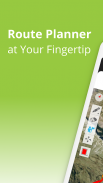
TouchTrails è un pianificatore di percorsi facile da usare per tutte le vostre avventure all'aperto. È sufficiente tracciare i percorsi sulla mappa con il dito per ottenere informazioni precise sulla distanza e profili altimetrici dettagliati.
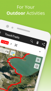
Pianificate i percorsi per il vostro prossimo giro in bicicletta o per le vostre escursioni di più giorni. Poi seguiteli con la navigazione vocale turn-by-turn.
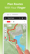
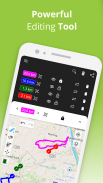
Pianificare e personalizzare i percorsi
Disegnate percorsi ovunque con il dito. La funzione "snap to road" consente di mantenere la rotta, ma si può anche andare completamente fuori strada. TouchTrails vi offre la flessibilità di creare percorsi adatti alle vostre esigenze. Dividete i percorsi, cancellatene alcune parti o collegateli.
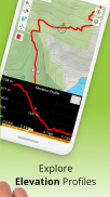
Misurare la distanza e l'altitudine
Misurazioni accurate della distanza e profili altimetrici dettagliati vi aiutano a capire quanto lontano e quanto in alto vi porterà la vostra avventura.
Aggiungere e modificare i waypoint
Con i waypoint potete arricchire la vostra mappa con punti salienti, suggerimenti e punti di interesse. Un'ampia libreria di icone di waypoint consente di personalizzare la mappa.
Tracciatore GPS
Registrate le vostre avventure con il localizzatore GPS. Salvate, modificate o condividete i vostri viaggi con gli amici.
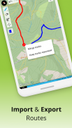
Visualizzatore GPX
Avete trovato il percorso perfetto sul web? Importate i file GPX da qualsiasi luogo. Navigate lungo i percorsi, misurate le distanze e analizzate i profili altimetrici. Modificateli come volete.
Percorsi multipli su una mappa
Non siete limitati a un solo percorso su una mappa. TouchTrails consente di visualizzare più percorsi contemporaneamente su una mappa. La flessibilità di TouchTrails consente anche di combinare e collegare percorsi provenienti da fonti diverse.
Condividere i percorsi
Inviate i vostri percorsi agli amici e condividete con loro la vostra avventura.
TouchTrails è l'applicazione di pianificazione dei percorsi, tracciamento GPS e navigazione perfetta per tutti i tipi di avventure all'aperto, tra cui:
• Corsa, passeggiate ed escursioni
• Ciclismo e mountain bike
• Motociclismo
• Overlanding
• Sci
• Mantrailing
• e molto altro ancora!
TouchTrails Premium
Passate a TouchTrails Premium per avere ancora più potenza!
• Aggancio alla strada
◦ TouchTrails si aggancia immediatamente a qualsiasi strada, pista ciclabile o sentiero escursionistico.
• Navigazione turn-by-turn
◦ Avverte l'utente quando esce dal percorso
◦ Indicazioni turn-by-turn via audio
• Accesso a oltre 100 simboli per la personalizzazione dei waypoint
• Salvataggio di un numero illimitato di percorsi
• Esportazione di file GPX
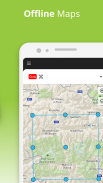
• Mappe offline per utilizzare TouchTrails anche quando internet non è disponibile o è inaffidabile
Per assistenza e suggerimenti, visitate il sito
https://www.touchtrails.com/docs/user-guide
Installate subito TouchTrails e vivete avventure indimenticabili! 🌲🚴🏃
TouchTrails: Escursioni, Bici - Versione 2.13.12
(24-05-2025)
TouchTrails: Escursioni, Bici - Informazioni APK
Versione APK: 2.13.12Pacchetto: com.wolfgangknecht.sketchatrackUltima versione di TouchTrails: Escursioni, Bici
Altre versioni


App nella stessa categoria

Potrebbe piacerti anche...


